About the fourth time I got off trail on the way to Arrowhead Lake, the trail I was to be on—or given the snow—over, the Pacific Crest Trail, was according to my Gaia app about 200 feet to my right and at least 5 feet below me. Actually, given the 700 feet elevation gain I had, maybe 6 feet below me.
This was my third time on snowshoes this year, the first two having been from my house into Alton Baker park for a couple of miles, right after we had 6 inches of snow, good to see after such a hot, dry year.

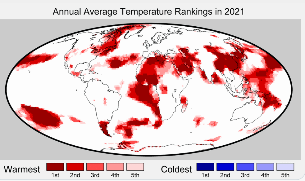
I keep telling people summer is overrated, and I think finally a few more now believe me. I can always put on warmer clothes; there is a limit to how much I can take off. Still, I hear talk about every day there is a little more light, and soon there will be the “blissful days of summer.” Amazingly, that is still said, forgetting all the days I wear an N95 for smoke, check the nifc.gov daily for fire news, carry my portable air quality indicator, and put up with record heat. The global map for 2021 temperatures shows red blotches all over the world like a bad rash for the top 1,5 and 10 years of warmth. There is not one single blue blotch for cold.
My second snowshoe was into town to my local Dutch Brothers, where I am still recognized. I bought a decaf white chocolate mocha for only a dollar, so I tipped the barista two, read the Eugene Weekly on the bench, and then continued in a 4.5 mile loop back by Autzen Stadium, and then directly through the park—on no path at all— by a couple of seasonal ponds I had never known were there, and back home. At least I got on snowshoes before the beginning of the year, but I hadn’t yet been up in the mountains.
The day I went up to Gold Lake Sno-Park, 70 miles southeast and a mile up from home, it was 25 and clear at the trailhead when I arrived. I headed south towards Bechtel Shelter, one of two in the park on the south side of Highway 58. Surprisingly, I missed the turn for the usual way I go to the shelter, but that was minor, since the snow covered road-trail led by the shelter as well and climbed more gradually. The snow was hard, and I stayed on top where snowshoe tracks from the day before were oval holes punched below to green branches.

I stopped briefly at Bechtel, noting that unlike past years where I could walk right in from ground level, I now had to go down three feet to go inside, but I wasn’t interested in stopping there. I climbed back to the road and was happy to see ski tracks head south towards Midnight Lake, about three-quarters of a mile, and Arrowhead Lake, a mile and a half further.
I had been to Arrowhead twice before, found it pretty, quiet, and a good hike on snowshoes. I was going to go again last March, but the vaccination drive occupied my time, and I never did make it back out there.
About 100 yards past the Midnight Lake turnoff the ski tracks I was following just stopped. I was now on my own, looking for a slight depression in front of me that showed where the PCT was. There are blue markers on snowshoe trails in the Sno-Park, but in the Diamond Peak wilderness, nothing is marked. I figured I could remember part of the trail, and the track I had mapped on Gaia two years ago would guide me if I couldn’t. In winter woods many open gaps look like trails, and it is easy to follow them until they suddenly stop. That’s why we mark them with blue diamonds and have Sno-Parks. Within a few minutes, I was off trail.
First thing I did was admit it. Surprisingly as that may seem, it helps, because it avoids the “let’s go a little further and see,”approach, trying to make trails out of open space that isn’t a trail. I’ve done that with “moving islands” in the Boundary Waters so they could fit the map; I thought it was just fine that there was a road nearby on the Appalachian Trail in North Carolina, even when there shouldn’t have been, and other foolishness. I stopped and looked at the app. Gaia showed the trail to my right, so I moved right. I did this twice and still hadn’t closed the gap much, and then I remembered I have a tendency to go 45 degrees right when I want to go 90 degrees right. Right means hard right, the computer term of which is “force quit.” Once I force quit and did a right face-forward march I found the trail and was again fine for maybe a half mile, before I again realized again I wasn’t on it. Two minutes later, I was on trail, repeating that a couple more times. I had hoped to get to Arrowhead Lake for an early lunch, and I began to think I might turn around, and retrace my steps, but I the trail became easier to see, then only three-tenths of a mile from Arrowhead, so I kept going. At least in the winter, if it is not actively snowing, I can always easily backtrack. I finally was close enough to see a gap to my right, and 50 yards late reached the path going to the lake.
Arrowhead is well named, with the point of the arrow headed towards the PCT, and the base to the northwest. I had eaten lunch out on the lake once before; this time I thought about trying to go across the lake in bright sunshine. It had been cold for a long time in the high country, so while I ventured out slowly, first umping up and down, then pushing my poles in hard, there was no cracking of ice and indeed plain quiet. Snow and trees muffle sound, and nobody was out there. I knew why I had come back. I had lunch on a shoreline where I could lean up on the bank and look at my footprints coming across, the PCT a little further away, blue sky above me. I had had my rain jacket off for the last 2 hours, but I know at lunch I would cool off and put it on right away. Savor is the right word to describe the actual enjoyment of enjoying something.


While eating, I thought about what I did last year on the return trip when I headed over to Eagle’s Overlook and then up and over Diamond Peak View back to the car. But that was another 7 miles, and while I might be able to do it, I doubted I would enjoy the effort. I certainly would not savor it.
Big decision having been made for the day, I was surprised the “far off” shore took me only about 5 minutes on snowshoes. The other two times I had been here, it seemed too far to go. I could probably walk around the lake in a half hour. Maybe next time I will do just that. In the meantime, I would return almost the way I came. It’s always interesting to see where I got off trail and ask myself how I did that.
“Are you going out the way you came in?” we once asked a pair of travelers in the Boundary Waters, who had told us earlier of the difficulty in getting to Kahshahapiwi Lake, a beautiful place but reachable only with a lot of work on long, muddy, wet, poorly marked portages. There were six entries, and I had been in on five of them, not doing the portage that was listed as, “Avoid at all costs.”
“No,” he replied. “We’re going out the way YOU came in.”

January 19, 2022 at 09:43 |
Thanks for taking me along and making snowshoes and winter navigation sound inviting. As always, terrific writing and a great read.