Archive for October, 2017

FILLING HOLES IN THE PERSONAL MAP

October 27, 2017

I spend far too much time looking at wilderness maps, hours looking at places I haven’t been, wondering what’s out there, and whether I have the health and the years left to get into those places.  Mind you, I’m not complaining.  I’ve been blessed far beyond most in what I’ve seen.  But I long to see more.  I always will.  I have large maps of the Oakridge, Oregon area, which include both the Diamond Peak and the Waldo Lake Wildernesses.  I have one of The Three Sisters Wilderness, others of the Mt. Washington, Drift Creek, Rock Creek, and Cummins Creek Wildernesses.  These are in addition to the Sullivan books I have which describe every major hike in Oregon, most of which I haven’t done or will do.  I bought a map of Olympic National Park the other day at REI.  I backpacked Olympic in the late ‘80s but haven’t been back since ’92. I’ve been staring at the map a lot this past week, deciding that I’ve got to go back there next summer for a few days.

IMG_9062.JPG

Oakridge area map: the town is upper left, Waldo Lake upper right

IMG_9064.JPG

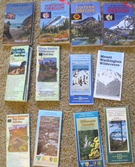
A selection of books and maps.  Other than the Coast book, I’ve done maybe three hikes in the other three books.  Terrible.

A couple of years ago, I found places like Moon Point/Young’s Rock, which I got in my craw until I finally drove out there and hiked nearly 3000 vertical feet, past Young’s Rock but not to Moon Point, being stopped by snow.  I found that the bottom part of the hike was too long to lead, additionally with a really nasty climb out in the open,  so six weeks later, I went out there, drove 3 miles up a Forest Service Road and found a way to the trail, taking it to the top and seeing Moon Point.  I led the hike about a month after that, so others could see it, without having to hike more than about 2000 vertical feet.  Such a deal.

A friend told me about Foley Ridge, not far from Eugene, so I went in there twice this past year, the first time to Substitute Point, which is the closest spot to Eugene over 6000 feet.  Beautiful place.  Then, a few weeks later, I did a solo 21.5 miler in to the Three Sisters Wilderness to see some of the most beautiful Cascade scenery imaginable.  The whole area burned a month later.  I’m so glad I went when I did.

IMG_9066.JPG

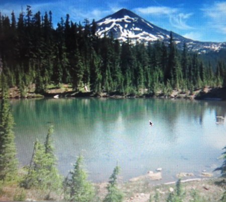
Husband Lake and South Sister before the fire

I looked for a long time at walking around Waldo Lake, Oregon’s second largest, starting not long after I arrived here in 2014.  I never got around to doing it, but I never forgot it, either.  Finally, I said the what the hell, I was going to do it.  I went mid-week and had a great hike—20.3 miles, nobody out there, nice lake, and 4 miles of trail with ripe huckleberries alongside that I could grab without stopping.  Did the hike in just over 6 hours and tried to lead it last week, but it rained too hard, and there was snow, too, up there.  I have limits.

Because of wanting to do something the day I couldn’t do Waldo, I had looked at the map and found a couple of trails that were used mostly used by mountain bikers.  One looked interesting, Heckletooth Mountain, a low elevation foothill.  I figured since the Club hadn’t had hikes here, it might not be very interesting.  On the other hand, I kept looking at the mileage and the fact it was close to Eugene, and thought why not?  I put it on the schedule to see if others wanted to come along, and I got three takers.  I later learned a fourth person was packed and ready to show up, then woke up to heavy rain and went back to sleep.  Couldn’t say I blamed him.

That morning, we were getting pounded by an atmospheric river event, a nice term, where there is a stream of moisture extending—in this case from Japan— to the Pacific Northwest.  We didn’t bear the brunt of it, but we got plenty of rain.  It hit the night before and was coming down hard when we four met at the local community college parking lot—Randy, the most experienced, Steve, the strongest, and Lynn, the fastest. I provided the idea.  And the car.

What the heck, we all had rain gear, and I wanted to see how good—or bad—my waterproofing was.  It wasn’t a cold rain for autumn and predicted to end by noon.  So off we went, 42 miles later almost missing the trailhead outside of Oakridge.  We started off with the trail’s having flowing water, a good sign in autumn, and when we took our second break about 3 miles in, I mentioned that the hike to Heckletooth might be a mile more each way than I anticipated.  I set a turn around time for 10:45.

Lynn piped up, “Well, if we are within a half mile, I want to do it.”  Liked her attitude.

We hiked through absolutely stunning yellows of Big Leaf maples and oranges of Vine maples.  It was great.  At times, I thought the sun was coming out, because it was so bright with yellow. Everybody was doing fine, and we climbed steadily the last two miles to Heckletooth, where the map showed the trail would go by the summit, not up.  Turned out the map was wrong.  We climbed to the top of the 3670 foot mountain, about a half mile vertical above Highway 58 below us, and looked out on dense fog.  You can’t have everything, but I liked the rain and loved the colors, even if I couldn’t see too much.

Each of us had been up Highway 58 probably three dozen or more times and never once knew this mountain was so close.  Nobody knew what a Heckletooth was, which turned out to be an implement for cutting grass last century—or maybe THAT last century, since I tend to think of the 19th century as last.

It was chilly on top, as our sweat plus the wind quickly cooling us.  We moved back down the trail a little for shelter and maybe a 5 minute lunch.  Randy wasn’t feeling well and didn’t eat, which explained why he was lagging 50 yards back when he can usually out climb me.  Steve had a big breakfast, not that it seemed to slow him down any.  Lynn ate faster than I, so I grabbed a protein bar and started eating it on the way down.  Everything I had on was wet with rain or sweat, but I was warm, and we were moving.

The colors were fabulous.  We stopped to take pictures, or I should say I did.  Lynn had one of those fingerprint locks, which is a great idea unless one is hiking in pouring rain and has a wet thumb.  I took what pictures I could easily take without drenching the electronics.  We came back down the way we came, 5.5 miles instead of 4, and went by a trail junction to Aubrey Mountain, which is a bit lower but reportedly has good views.  Not wishing to hike an extra 5 miles, we kept going back to the car.  Normally, I might have done Aubrey, but this day was enough.

Near the bottom, Lynn said that that Heckletooth ought to be a regular fall hike on the schedule.  I agreed, so much so that I put Aubrey Mountain on this weekend and figured I would go alone if nobody else were interested.  Got one taker so far, and Lynn is really upset that she had something else scheduled.  It’s going to be sunny and dry.


IMG_9065


THIN VENEER

October 11, 2017

In 1992, I spent six months as a volunteer wilderness ranger for the US Forest Service in the Boundary Waters Canoe Area (BWCA). For the next eight summers, I spent a week n the BWCA with the late Mike Manlove, a remarkably wise woodsman, father, husband, and friend.  One raw, late summer day, Mike and I were on large, oval-shaped Alice Lake, with only a few small islands at the northeast corner.  As we were checking out all 11 campsites on the lake, we pulled up on one sandy site, lovely, I suppose, if it were a hot summer day,  but then wet, cold, and with a lot of recently abandoned gear.  Mike shook his head as we cleaned the site, knowing we would have to haul a lot of trash out. “These people got out of their comfort zone,” Mike said, folding a wet shirt and picking up some wet food containers. “Once that happens, all the good thoughts about Leave No Trace get left behind. All people want is to get out of here.” The idea of treating the wilderness properly is a thin veneer of behavior, which under adverse circumstances may melt away like ice off a boreal lake in spring, leaving one hell-bent for whatever leather they have on their boots to leave the woods.

I’ve been out of my comfort zone, and I know what Mike was referring to.  One doesn’t want to consider Leave No Trace if facing head winds, rain, cold, 3 days’ travel from town and 15 miles to travel that day.  The best defense against such conditions is to be adequately equipped to travel in inclement weather. There was a time when we had only our eyes, ears, and nose to make weather forecasts, and every night in the North Woods one put things under cover, because it might rain, even if the evening were clear.

Today, technology allows us in the wilderness to get accurate weather forecasts and radar.  We can move further than planned on sunny days if we know the next day is likely to be wet.  Before a recent trip with a friend, he was almost obsessed with the weather forecasts, at one point texting me “Rain+Cold= Misery”.  I’ve canoed in a lot of rain and cold; it’s challenging, but it need not be miserable. I’ve paddled 15 miles in heavy rain more than once, put up a tent, changed my clothes, found dry wood, and started a fire. Yes, I was wet, but once I changed my clothes and sat by the fire, I was warm. I gave my friend a chance to not go; while he didn’t take me up on it, I think he might have been happier had he stayed.

On the first part of the trip, my friend was far more neat than I, his tent meticulously placed and his cook gear, food, and gear neatly stacked near the fireplace. I was impressed and in fact a little jealous.

The penultimate night, we had a strong thunderstorm move through.  Fortunately, it was at night, and yes, I had the camp saw in the tent with me, in order to saw any tree that fell on my tent, assuming I survived the impact.  I stayed safe and dry, but my friend’s tent was pitched in a small depression so that his sleeping bag and some gear got wet.

We needed to move a few miles the next day so that we would be close enough to the take out point to exit the woods on time.  The next morning, after the rain stopped, I started packing and taking my gear down to the canoe.  My friend was not only concerned about his sleeping bag’s being wet but his tent.  To me, packing a wet tent is not enjoyable, but something I’ve done many times. It usually dries shortly after I pitch it the next day, and if not, I have a plastic sheet that lines the floor.  My friend was clearly uncomfortable with his wet gear, folding the tent so quickly it barely fit into the sack.  The tent fly, which is normally folded with the tent, wasn’t, and we ended up carrying it and the tent separately over the portages.  I realized that he was out of his comfort zone. When we reached the lake where we were staying, I found a west-facing campsite where the late afternoon sun could dry everything. It did.

Being outside of one’s comfort zone is of course part of war.  Part VII of Ken Burns’s recent Vietnam documentary was “The Veneer of Civilization,” how some young American men, decent people in civilian life, became the ugliest side of mankind during war.  Burns’s documentary took the wraps off, hearing from brave men, taken out of their comfort zone, who were forever changed.  War strips the veneer “civil” from civilization. We saw how Germany, so strong in the sciences that my father-in-law, a physician, had to learn German in the 1930s, because the best medical research was written in German.  These same people murdered people in places called Auschwitz or Thereseinstadt; I saw the signs in Mauthausen referring to parachutists without parachutes, where one had a choice to jump down on to granite 50 feet below or be shot.  Many committed suicide by trying to escape over electrified fences, to avoid places called “Gaskammer” or slowly starving to death.

The veneer has been badly scraped here in America since 20 January, and it was completely removed in Charlottesville and Las Vegas.  Congress used to be civil; the civility has been stretched and broken.  The veneer has disappeared in the halls of power, when one party has pushed legislation that was written in secret, not taken through the committee process, and brought for a vote within a few days of its having been written.  There isn’t even the pretense that there is respect.  Instead, it is push it through, even if the rules have to be changed.

There was a time when letters to the editor were the only way most of us could express an opinion. Editors filtered the letters, and there was a decent layer of veneer in public media. The Internet has spawned anonymity in which people spew vitriol without consequences. Much of what appears is poorly written, not factual, illogical, difficult to understand, hateful, adding nothing to public discourse.  There is seldom a simple “I disagree” without an ad hominem attack.  Covey’s Fifth Law: “Seek first to Understand then to be Understood,” one of the most powerful rules I used in management, is absent. I can’t write a letter to the editor or a blog post without letting it sit at least 24 hours, often longer, so that I have time to see if my original thoughts still seem right.  Often, they have significantly moderated.  On social media, much of what I write I delete before posting.

Just as astronauts can see the thin veneer of an atmosphere that allows us to breathe; just as a thin veneer of topsoil allows us to grow things; just as a thin veneer of pollinators allows flowering plants to produce food, so is there a thin veneer of civilized behavior that keeps us from descending into a hell that will destroy us.  In the woods, my veneer is experience and proper gear. In society, it is politeness, respect, listening, measured speech, and filtering one’s thoughts before expression.

We need every last bit of veneer today.