I stood in my snowshoes on the side of a snow-covered hill, deep in the woods north of Willamette Pass, near the Pacific Crest Trail (PCT), but not sure where it was.
That was a problem. I was 5 miles from the road, alone, glad I had a GPS. I had two choices: retrace my steps, which were easily visible in deep snow, 8 miles back to where I started, or keep going a shorter distance, but unmarked, trusting in the GPS that I was a half mile from familiar Upper Rosary Lake.
“My best hikes are the ones I do solo,” put me in this situation. I recently blurted those words to some hiking friends, a few of whom had been on many of the 135 hikes I have led as part of the Club. The one person in my life who doesn’t lecture me on hiking alone is my wife. I’m sure she would feel better if I hiked with another person. Or not. She knows my best hikes are solo. I would rather lead hikes than be a participant. I’d still prefer being solo.
One of the reasons I did this snowshoe was her comment the night before, “This is the kind of hike you like doing.” She’s right. I’ve done three 20 milers alone here in Oregon, plus more than ten others pushing 20 miles, and they were great. I had never snowshoed more than ten.
Anyway, it was a Thursday, and I had driven southeast past Oakridge up into the Cascades. I had snowshoed two weeks earlier with a friend in Gold Lake Sno-Park. We got to Bechtel Shelter, having lunch at Odell Lake Overlook. It was a good snowshoe—just under 6 miles with a modest elevation gain of about 500 feet—and my hiking partner said that was his last snowshoe of the year.

Odell Lake Overlook
While it was April, we had continued cool weather in the mountains along with some snow. I wanted to see Maiden Peak Shelter, one mostly for cross-country skiers, because of its distance, 11.5 miles roundtrip. I thought it could be done on snowshoes, and with a little more effort, maybe even a loop. Nobody was going to do it with me, and the thought messed with my mind long enough until I decided abruptly on Wednesday I was going to do it. I told my wife my planned route, other routes I might take, the time I should be done, and the time to start making calls.
The weather was clear, not cold, with a forecast of some snow flurries, and I arrived at Gold Lake Sno-Park before 9. Sno-Parks are public facilities with trails for skiers and snowshoers. Many have shelters built by volunteers, for day or overnight use. One has to buy a winter permit ($25) or can pay $5 for a day pass. Nobody was there in late April. Last year, I had had my best and last snowshoe on May 2. Nobody was out there, either.
I wasn’t going to snowshoe at the Sno-Park this time, crossing Highway 58 to get on Gold Lake Road. The snow wasn’t too deep, but a past skier’s tracks were better for me to use. Normally, one should not snowshoe on ski tracks, but this time of year I wasn’t going to quibble, and I doubted I would see many skiers or snowshoers. While cool, I started without my rain jacket. I tell people at the start of a difficult hike if they are warm, they have too much on. I would be warm on this one.
About 1.6 miles in, the Maiden Peak trail began by a hairpin bend off the road. Several tracks showed where people had cut the switchback in snow, and while that shouldn’t be done on bare ground, it is fine in winter. I did that and took a brief drink break. Seven of my 8 Afib episodes have begun during or right after a hike, and I finally wondered whether dehydration and lack of food might be a trigger. Left to my own devices, I will hike miles without drinking in Oregon. I bought some Gatorade and have made myself drink every few miles, no more than an hour without drinking.

Fuji Mountain from Maiden Peak Trail
The trail was flat for another mile and then climbed steeply from Skyline Creek to the Pacific Crest Trail, where the ski tracks went straight and I turned south. Now at 6000’, having climbed over a thousand, the snow was deeper. I gained more elevation, passing some tree wells on an angle, which I carefully avoided, since falling into the conical well, with the trunk at the center, was a significant risk to me. I was in the right place, but the mileage seemed less than expected, so I wasn’t totally certain I was on the path to the shelter. Finally, after 5.3 miles, I saw a sign pointing left to the shelter. While it wasn’t obvious, I found it soon enough, a nice, closed well-built structure at the edge of a meadow. This wasn’t a three-sided open one, as many are, but a closed roomy one with even a loft.

Maiden Peak Shelter

Maiden Peak Shelter. There is a stove, wood, and the ladder to the loft is visible
I entered it, snowshoes still on, sat down, and had a quick lunch. I wasn’t tired, but I needed a break before the afternoon return. I had two choices, return the way I came or keep heading south to the Rosary Lakes, where I had been three other times this winter. One way, I would have my tracks to help, the other way I would probably (I hoped) pick up tracks at the Rosary Lakes, making my trip easier. I chose the latter.
There are blue diamonds attached to trees for snowshoe trails, put high enough because one is standing on snow, well off the forest floor, the ground often covered with several feet of snow. I have adopted one such trail in the area where it is my responsibility to see that the diamonds are up. So far, I had done well with the diamonds showing a clear path, but a half mile after lunch, I “ran out of diamonds.” That put me in the situation, not on the trail, becoming fatigued, toying with the idea of returning the way I came, but wanting to continue.
Even if I reached my first goal, Upper Rosary Lake, I would have 4 more miles just to get to the road, which was another mile from my car. My GPS showed that the best route to take was along a contour, and my watch altimeter would help keep me there. After 15 minutes of slogging, I finally saw familiar terrain and the lake ahead and below me. To my disappointment, there were no tracks, which would have made it easier. Snowshoeing in moderately deep untracked snow, which I had done for the past 4 miles, is difficult, and I would do it for the next four. I thought briefly about climbing to Tait’s Loop, my adopted trail, but decided I had done enough climbing. As if to second the notion, my legs cramping, despite my hydration, and that sealed my decision. Rather than taking switchbacks to the lake, I went straight downhill to it.
I elected to walk on the snow-covered lake along the shoreline, needing something flat on which to walk for a while. At the far end, I took the short path to Middle Rosary, did the same thing, and then left it and went over the small hill to Lower Rosary, where I had to walk in the woods, since the ice was clearly too thin. At the far end, I left the lake and had a 3 mile snowshoe slightly downhill back to Highway 58. I was slower, but I was no longer cramping.
I reached Highway 58 after 11.5 miles, still having a mile walk on pavement to the car. I could deal with that. I had done a loop, seen a shelter, three lakes, was on the PCT (at least part of it), got off trail, navigated to a familiar place, and got myself back to the car. Great snowshoe. Solitude is good. I won’t be able to do this much longer in my life.
But I did it once.
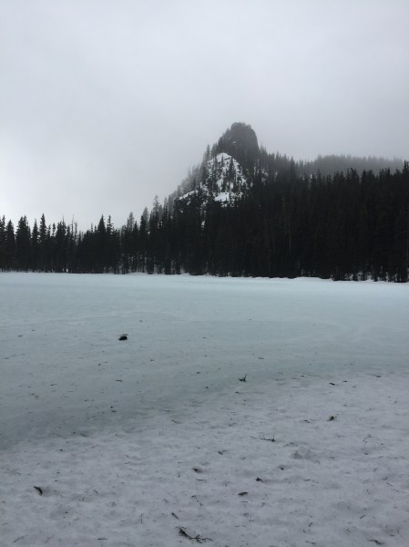
Pulpit Rock from Upper Rosary Lake