Archive for April, 2025

THE CABLE

April 6, 2025

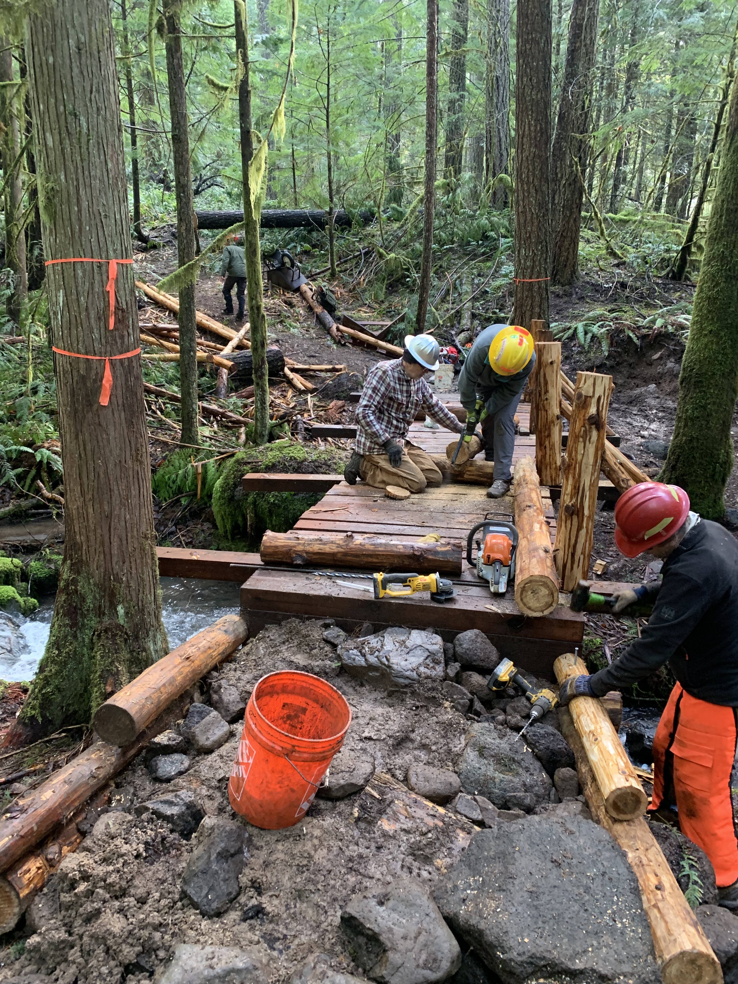
Amazingly, it wasn’t raining, despite the forecast. It sure was wet in the woods, though, and the two streams that we had put bridges across in the past 16 months were really flowing. The Crew was back at Cloverpatch working on the third bridge. 

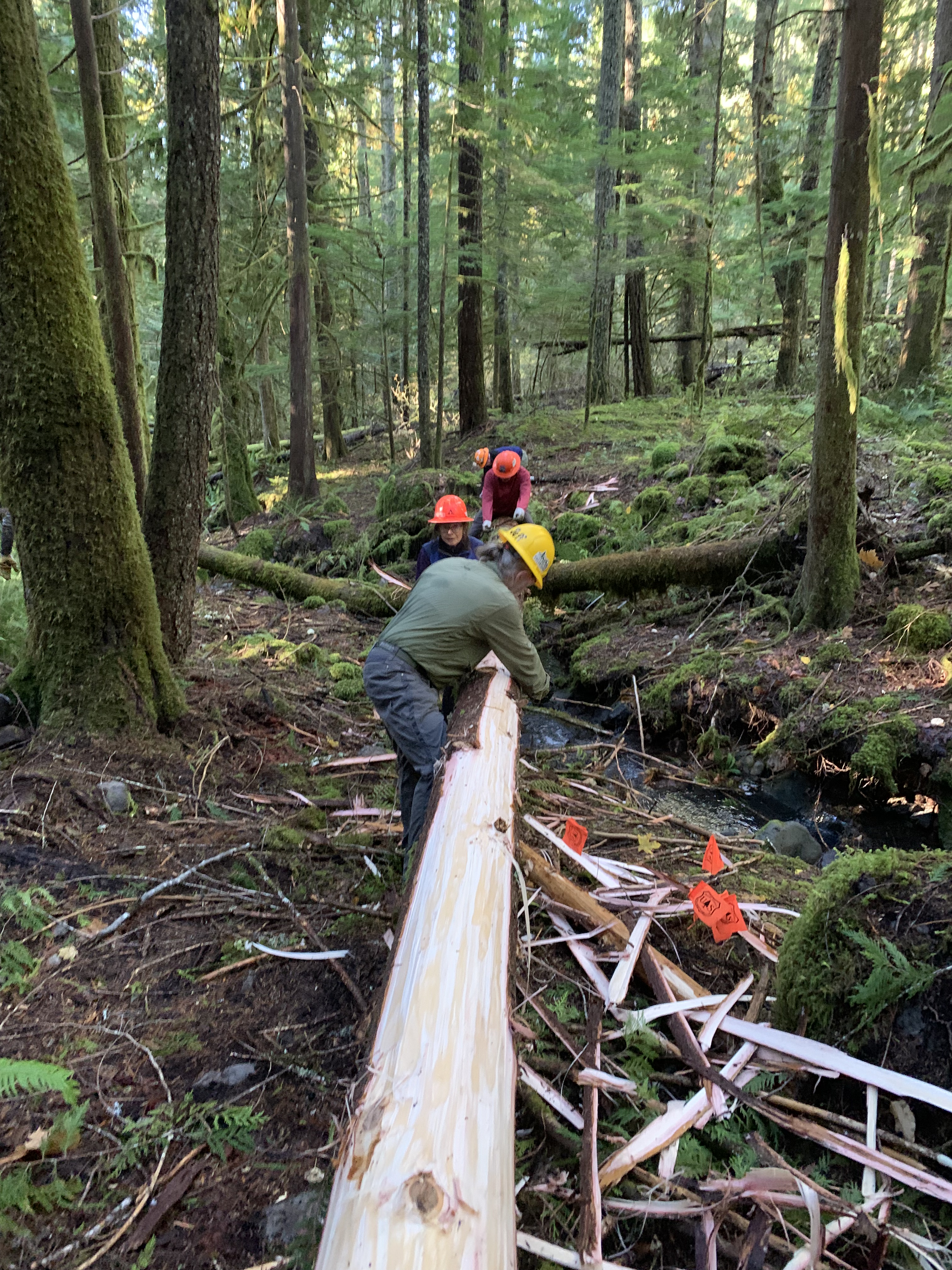
I had already done some work here, having carried in my share of tools, planks, and one memorable day figured out how to use a small log as a runner for a 1-2 ton stringer to get it to the bridge site. But the last few times out, I was either relegated to, or had the honor of, being the lead for the work party building the trail to the next and last bridge site, a half mile further. After three days with tread tools there we were now within about 50 feet of the end, maybe a bit more given some rerouting that I thought might be necessary.

But on this wet day, I stayed with the rest of the eight person crew, hiking in, debarking cedar logs that would be used for stringers, posts, supports, and rails, a couple hundred linear feet required. Counting the posts, that comprised about 1000 square feet of bark that needing removal, although I was the only one crazy enough to calculate that.

Additionally, we had rock “cribs” needing filling so stringers and sills, the latter large diameter shorter length logs perpendicular to the crossing stringers, would rest minimizing wetness and rotting. We needed to make a ramp at each end for smooth travel at both ends of the 21 foot long bridge. This entailed more rocks, soil to fill in the spaces, and repeating until we had a smooth ramp.

I used a straight draw knife, sharp 10 inch blade, couple inches wide, beveled, handle at each end. Grabbing each handle, one straddled the log, leaned forward, put the blade under the bark, and pulled towards oneself,  strips of bark peeling off. In the right season, strips could be several feet long, but this time of year two feet was good. We cut down to the cambium, worked our way down the log, and rotated it, continuing. I debarked a 12 and a 25 footer and then took a break collecting rocks, which were plentiful in the Tire Creek area. I had filled the lower two feet of the crib several weeks ago mostly by myself. Now, the rocks needed to go above the sills to support the ramp, to take up volume, each rock removing the need for the equivalent volume of mineral soil.

I was not the strongest. Jeff was carrying rocks I would roll, and in some instances he stopped to talk while carrying. Wow. My legs were good, so I could still do my part by carrying smaller rocks with more trips, taking time from that task to knock some rocks out of a root wad with a shovel. Before I knew it, time for lunch. I was beat. Rock work does that.

After eating, I rolled left and gradually stood, now needing to move rocks to the crib on the other side of the bridge. There were no rock shortages there, the distance shorter, but the weight the same. Most of the crew was about a decade younger than I, although Chris was only a year younger. He may be a little slower the past two years, but so am I; there is nothing wrong with his arm strength.

We didn’t finish, which would require more visits, and hiked out a mile and a half with plenty of uphill. For the first part, in addition to my pack, I carried only a light strap. Easy enough. I caught up with Hal, who had stopped, putting down 20 yards of coiled cable for a no longer needed come-a-long. I was polite, asking if he wanted to trade the cable for my light strap. I expected—and hoped—he would say he was fine.

“Would you? To the top of the next hill?” Crap. He’s serious.

I picked up the cable, coiled, 35 pounds plus. I let my right arm take the weight, and I started up the hill. My hiking speed dropped like a stone, and I went uphill about the same rate I could push one.  But I was going to carry it up the hill, and once I got there, I wasn’t going to relinquish it. I would carry it to the trailhead. 

I did make it. I finally felt useful; perhaps this will be another good year.

Constructing the bridge.
Debarking a stringer.

WRONG TRAIL

April 2, 2025

I don’t know why I turned around. 

I was looking at a “mess,” term I use for trail blocking organic material: several broken large logs, assorted attached and unattached branches, other greenery, and mud, noting where it was—on the descent to Harper Creek on the South Willamette Trail—and the size.  I must have heard something, despite my removing my hearing aids due to the rain.

A young woman stood about 10 yards from me uphill on the trail. Didn’t see a pack; she wore sneakers, not the best foot gear to hike, especially on a wet day, although I have encountered this before, once in pouring rain where the wearer planned to wear a plastic bag around her feet. I strongly suggested she not hike; she went anyway.

“Is this the Eula Ridge Trail?”

Uh Oh.  She’s going to be unhappy with my answer.  

“No, This is the South Willamette Trail. Eula Ridge is back about a mile. Remember where the trail forked? You went right. You needed to go left.”

About a quarter mile from the trailhead, the trail bifurcated; to the right, a sign on a tree said this was the South Willamette Trail (SWT), 5.1 miles to Hardesty Mountain Trail. Left went up Eula Ridge, which joined Hardesty Mountain Trail near the top of the mountain with the same name. It was a 14 mile loop. The junction was a mile back. She hiked that mile, including a nasty stream crossing, and had to climb over logs in eight different places. I knew that because I had just hiked it, scouting the trail for logs needing removal. At least, she didn’t have to traverse the mess we were at. If there had been fewer blowdowns, I would have been further along the trail when she caught up with me, and she would be further from where she was supposed to have gone.

Mess on the South Willamette Trail

This was neither time nor place to suggest a map, a compass, or better clothing. Most of us have been guilty of shortfalls in outfitting or taking hikes. I hoped she would learn something today from her mistake. I like maps, and carry a compass, which I almost never use. The times I have used it, however, were important. Next time, maybe she will prepare in advance for the trip. On my trips to areas I haven’t seen for awhile, I usually check a map or CalTopo, and I have good trail memory. 

I have worked the SWT 17 days; I have hiked it and Hardesty at least a dozen other times. I had power brushed the section where we both were now last year. I was wearing a hard hat on a day that promised wind, I had two small saws with me, lunch, water, and a space blanket in my pack.  My wife knew where I had gone and what time I should be done. This woman was hiking alone. I understand that and don’t criticize others who do; solitary hikes are often the best ones I take. Before I left the house, I threw in my golden yellow rain jacket, because it is better than my windbreaker. I ended up wearing it. 

The stream was 4 feet wide, 15 inches deep, flowing fast, which made me stop a bit to think whether it was worth crossing, and if so how I was going to do it. I had gaiters, faced upstream when I crossed—quickly—using my walking stick to triangulate. I had no problem, and while my boots were wet, my feet stayed dry.

I continued, scouting the next mile, stopping at the last log which I knew from the report. I figured out how to log out the trail, with two crews, one from the Eula Ridge side, where I started, the other from Crale Creek Road, where two years ago I found a shortcut to reach the high point on the SWT without a long hike from below. This day, I put a ribbon marker at the user trail leading to the main trail so workers could find it coming from the road. I had a good outing.

I was mildly concerned for the hiker, although not worried. She got well off track on a day where the weather was not forgiving, and which would cost her time and warmth. It bothered me that she missed the easily visible trail sign. Despite my familiarity with the trail, I had a dedicated GPS plus one on my phone, which did have reception. I want to know where I am, my altitude, my closest way out, and the time. Going into the woods should not be taken lightly. I knew the weather forecast and wore a sturdy rain jacket. My rain pants were old but serviceable. I had good boots and gaiters. My taking the time and gear shows respect I have for the country. 

There is a softer side, too. It is not enjoyable to be improperly equipped. I’ve been there and suffered. The SWT and other trails are lovely in spring. Water is everywhere. Violets, Trilliums, and Nuttall’s toothworts were blooming, Pacific Wrens were calling and even a vulture flew overhead. I had a great hike. I’m afraid she did not.

When I got back to the trailhead, I noted the right front tire on her vehicle was significantly low.

Sometimes bad days happen. See you on the trail and I hope not on a bad day.