Archive for May, 2016

TRAIL MEMORY

May 28, 2016

We were descending Marys Peak in the Coast Range to the cars, the last part of the hike’s being on a service road used to oversee the Corvallis watershed.  No vehicles were present, and from the blowdowns on the road, none had been there for some time. After about a mile, there was a trail heading off into the roadside brush, with a sign: “Trail Closed due to Operations in Area”.

The person hiking with me said, “Was that the way we went up?”

“No,” I replied.  “We entered about a half mile further.”

IMG_0530.JPG

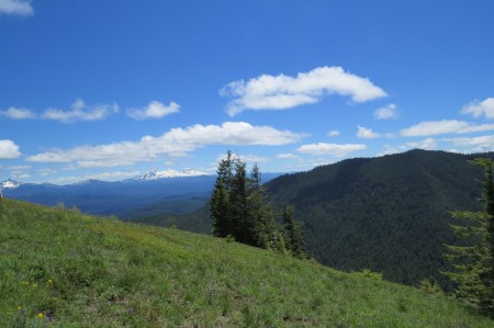
Three Sisters from Marys Peak (April 2014)

I am no longer surprised by these comments.  I was the trip leader, and there is no way I would take a group past a sign saying “Trail Closed.”  The trail we had taken 3 hours earlier ascended immediately in forest and this one stayed low and in brush.  But, as I have learned, what is sometimes obvious to me isn’t obvious to others.

“Where was that hike where I got so exhausted with the pack I was carrying that I fell?”

“Browder Ridge.”  I know where on the trail it occurred, too.

IMG_4761.JPG

Browder Ridge Summit with Mt. Jefferson in distance (2014)

“What mountain were we trying to climb last fall when we turned around because of weather?”

“Crescent Mountain.”  I know exactly where we turned around, and I will see it in a week when we go there.

IMG_1953.jpg

Crescent Mountain, on a day people did not belong at the top.  We turned around (2015).

IMG_1013.JPG

Crescent Mountain in June 2014, with lake of same name below.  It is about 5 miles and 2100′ vertical to the summit, where there was once an lookout.

IMG_1019.JPG

Mt. Washington (far left) and The Sisters from upper meadows of Crescent Mountain

Granted, many of these hikes I have done before, but after one time doing them, I have a sense in my mind of the trail.  I’ve only hiked Middle Pyramid once, but I can visualize the bottom of the trail, the open area with the cliffs high overhead, and the gradual climb up through the cliffs to the top.  My memory is good enough to help me as trip leader.  I am not a Jon Krakauer, who saved his life on Mt. Everest during the 1996 disaster, because when the storm hit, he had a sense of where the trail was and how to get back to shelter on the South Col.

IMG_2819.jpg

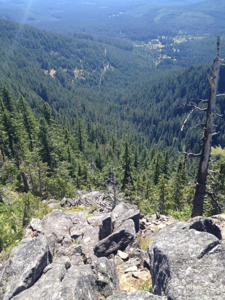
View down from summit of Middle Pyramid, 2014

IMG_2810.jpg

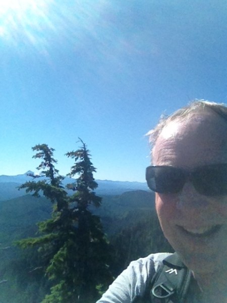
Author, summit of Middle Pyramid.  It’s a little more than 2 miles but climbs steeply.

I think trail memory is both natural and observational.  I remember trails without usually thinking about it.  I am not as good at remembering steep ascents or descents, perhaps because I tend to hold my speed constant on them, so they don’t stand out so much.

This isn’t to say I haven’t gotten turned around a few times in my life.  In 1998, on the Appalachian Trail, I rested sitting on a rock, and when I got up, retraced my steps about a mile before I realized the traffic I was hearing was a road I had previously crossed.  There was no road the way I was supposed to be going, and bells were going off in my head that something wasn’t right.  That was deeply embarrassing and likely due to fatigue.

In 2006, on Isle Royale, I was hiking at night back to Windigo after a wolf had visited my campsite.  It was late, but I wasn’t going to stay there with a wolf in the vicinity.  I knew that wolves didn’t attack healthy humans, but knowing that intellectually and being alone ten trail miles from the nearest person were two very different things.  It was time to sleep, not hike, but I was going, sunset or not.

Or what passed for sunset under thick clouds that promised snow.

In any case, with a small light, that I hoped would keep working, I went around a blowdown and continued.  But something didn’t seem right.  I had walked around a lot of the blowdown, maybe too much, and I couldn’t say for sure that the trail I was seeing was similar to where I had just been.  Jon Krakuer might have known.  But I had a sense—an uneasiness—that I was going the wrong way.  I stopped, found my compass, and took a bearing roughly the direction I was headed.  It should have been northeast; it was southwest.  I turned around and walked back to the blowdown, confirming my error, and found the trail sooner on the other side, eventually making it to Windigo.

ISLE ROYALE 154.jpg

Young moose, Isle Royale, taken from the campsite where 2 hours later I would see the wolf.  10 May 2006.

I’ve been cultivating these senses lately.  I’ve been slow to do this, because I am mostly a linear, analytical person who hasn’t much believed in them.  As I have spent more time in the woods as I got older, I started realizing if I weren’t sure where I was, it was wise to admit—out loud—that I was lost and do whatever was necessary to get myself on track again, usually meaning backtracking, sometimes back to the beginning and quitting the trip.  Trail memory is fine, unless I am on a trail that I have not trod.  I did that on Burntside Lake in 1992, when my map didn’t quite show where I entered the lake, but I reasoned the distance was short so that I would soon be navigating by my other maps.  That didn’t work, I was lost, and I backtracked the whole way.  I felt stupid, but at least I didn’t compound my mistake by continuing.

The last time I really messed up was on Mt. Pisgah, practically in Eugene’s city limits.  I hadn’t lived in Eugene at the time, and Pisgah is famous for two things: a large network of trails and even more poison oak.  The first time I climbed it, I thought I found a different route back to the parking lot.  I soon realized that the trail was not going there, or the Sun had moved its position in the sky.  Finally, I realized I was descending to a different parking lot.  Once there, I walked to a road I thought would take me where I wanted to go.  After a mile, I admitted I had no idea where I was, retraced my steps, and took a chance that a trail along the base of the mountain would get me back.  Had it not, I would have backtracked to the summit and down the trail I originally ascended.

Getting lost still embarrasses me, but I learn from it.  With GPS, I am able to know where I am and can try a different route.  Still, GPS is sometimes not enough to counter a sense that one’s direction is wrong.  GPS is also dependent upon not only battery power, but having a good connection with satellites.  Such connections may disappear In deep woods, and especially canyons.

Trail memory is also useful on those winter nights or difficult times in life, when one wants to escape civilization and find solitude in those hundreds—no, thousands—of trails across the continent.  I can go there in my mind: climb, breathe the air, hear the birds, see the flowers, and be alone.  I get great pleasure at looking at maps and saying to myself, “I’ve been out there.  I know what it looks like.”

IMG_6841.JPG

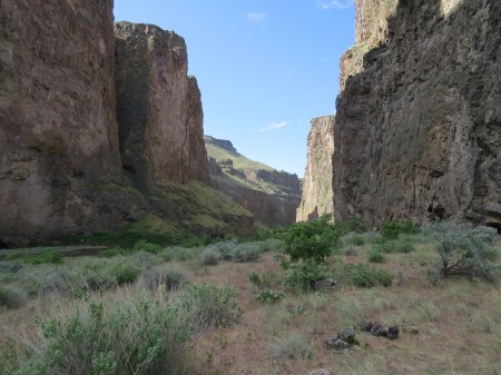
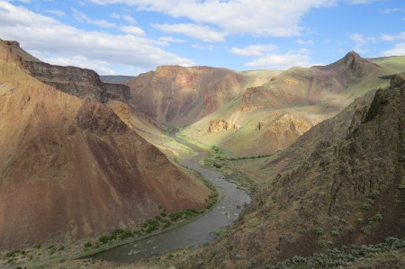
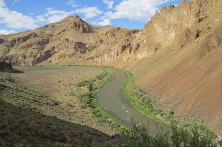
High Desert from the top of the canyon overlooking the Owyhee River, 2016.


LISTENING TO “NO”

May 23, 2016

For the third time on the trip, I had missed out hearing about something important going on, and I was annoyed.  The latest buzz I heard near my tent was about a hike somewhere up on the ridge behind us.  Who set that up?  Why didn’t I know about it?  I wondered.

A dozen of us from the Obsidian hiking club out of Eugene were rafting the Owyhee River in southeastern Oregon, a remote river few have heard of.  For river guides, the Owyhee is one they want on their resume. The prior four years, winter had not delivered a snowpack sufficient to produce enough meltwater to support rafting, but this year’s winter had been good, the river runnable; indeed, our guides had taken four groups down the Owyhee already. The snowpack, however, disappeared under April temperatures that were again 30 degrees above normal.  We had been told our mid-May trip was in jeopardy, and given the rapid fall in river flow, were certain we wouldn’t be able to do the trip.  Unexpected rain came, however, and the river flow stayed over 1000 CFS (cubic feet per second), slightly more than the 800 CFS  necessary to run the rapids. Not many would follow us in 2016.

The prior night had been the most special of the trip, I thought.  We camped in Green Dragon Canyon, a narrow chasm 1000 feet deep, maybe 50 yards on either side of the river before the cliffs began.  I often stared at the river, the walls, and the narrow patch of sky, saying how lucky I was.  One couldn’t have a better camp, and the next morning’s thunderstorm, echoing off the walls, echoed my thoughts.

IMG_7031.JPG

View from my tent, Green Dragon Canyon, Owyhee River

On this, our last full day on the Owyhee, we camped in a gorge with sedimentary rocks and compressed ash forming spires and faces and cats, orange columns below basalt rims on either side.  The upper rim was 1600’ above us, and I had heard the hike was going to the rim.  I came over to a group of 5 that was about to leave and asked to join.  Unfortunately, I didn’t have any other details.  That was a bad oversight on my part, for 1600 feet vertical is a major hike to take in late afternoon.

IMG_7108.JPG

The ridge we climbed.  I stopped about two-thirds of the way to the bottom of the upper rock ledge.

The pace at the outset was fast, very fast, too fast, and I fell behind, surprised.  One man dropped out within a minute.  Then I looked down and saw squirming bodies that looked like crushed mice.  And blood.  And intestines. A large Chukar suddenly flew off to my right.  I then realized I was seeing dying young birds that had just been stepped on by the hikers ahead of me.  I called out and they came back, in time to see the young birds struggle one last time before thankfully dying quickly.

One of the hikers, a woman, stood there in shock, her mouth open, totally appalled.  She had been in the lead group.  Another man said, “They are an introduced species,” as if that had anything to do with the fact that fast hikers, bent on speed and little else, had just killed birds in their home in a place we all loved and wanted to protect.  Some protection.

The woman replied, “So am I.”  She had been born in Japan and lived there 12 years.

Normally, I don’t think of omens, but this was not a good one.  The hikers, including the woman, continued as if nothing had happened, a blistering pace up the ridge, barely switching back at all.  I was not on a steep trail, which I can handle, but scree, large rocks, and nothing to hang on.  My walking stick didn’t come with me on the trip.  My stick had been my paddle.

The four regrouped periodically, and I caught up, just in time for them to go higher and faster.  Wow, they were good.  Then again, I had been in the kayak all day and had worked hard. Up I went, now 50 yards behind, well below the fourth hiker, grabbing rocks, bushes, anything I could.  I gained 100 meters elevation, 125, then 150, puffing.  I looked up at the receding group, and suddenly I heard a “NO” come from me.  I spoke the word audibly.

I stopped.  It had been a few weeks since I last vocalized a NO in the woods.  It occurred on a solo scouting trip past Young Rock on my way to Moon Point, outside of Oakridge, Oregon.  I had gone several miles and up nearly 3000 feet, through snow, over some difficult blowdowns, a few streams, until I encountered a trio of fallen giants that I couldn’t go neither up and around nor down and around.   Or through.  I was less than a half mile from my destination, but I said NO and turned around.

IMG_6681.JPG

Near where I said “NO” by Young’s Rock

NO sounds bad.  Negativity is not nice.  It means quit, failure, didn’t do it, wasn’t good enough, all those things.

It also can mean one has wisdom.

I did not like where I was, perched on the side of a ridge at a 45 degree angle.  On my own, given enough time, I could probably get to the top.  I didn’t know that the top they were going to was only another 75-100 meters.  I am literal, and the top of the ridge was 500 meters above our camp. Then I had to come down this stuff.  No matter; all I knew was that I was not going further. I listen to my “NO.”

I turned and stared in sudden wonder at the Owyhee, far below me.  I could see the last rapids we had done and the ones we would run the following morning, our last day on the river. That probably would be the last time I would ever see the river, although I am as cautious about saying the last time as I am saying the next time.  I may have extraordinary luck, or I may die. Stuff happens.

But what I saw as a result of my “NO” was a beautiful scene below me.  There are different kinds of orange, and for those who don’t appreciate the distinction, it is worth running the Owyhee, for the river is colored by geologic events that happened millions of years ago and by flowers that happened to bloom in the past week.

I would be careful on the way down, both for my sake and the sake of the locals.

IMG_7096.JPG

The Owyhee River from where I stopped.

IMG_7106.JPG

Sunset on the Owyhee

IMG_7103.JPG

“Cat Rock”, Shiprock at sunset.

IMG_7094.JPG

View upstream, where we saw eight Bighorns earlier that day

IMG_7092.JPG

One of the Bighorns.  Picture taken from a kayak being moved by the current.

JUXTAPOSITION

May 15, 2016

I found interesting a juxtaposition of articles in the newspaper about excessive classroom size in Eugene, and bonuses paid to Oregon football coaches 3 seasons ago.  The University (UO) paid $688,000 in bonuses, $490,000 for an insurance policy that was supposed to cover their cost, but apparently didn’t, and finally accepted a settlement of $242,000, lawyer fees not stated, meaning it cost UO at least $936,000 that year for football staff bonuses.

They didn’t win a national championship.

I knew Eugene was a big football town, but I underestimated how big. The head coach makes $3.5 million; the rest of the coaching staff altogether makes another $3.5—before bonuses.  The Science Factory, a small children’s museum near Autzen Stadium, gets a significant portion of its income from renting space on their lawn for tailgaters during home games. That’s “trickle down.”  For $7, a child can spend several hours in the exhibit hall with a lot of cool exhibitions.  Plus, there is a planetarium show where kids and parents learn about the night sky. They can find the North Star, which escaped slaves knew 150 years ago, and which very few Americans can find today.  Yet, 40% believe in astrology, and some wonder how Trump might become president.  Education matters.

For “$29 and up” (well into three figures for decent seats), one can see the Ducks play my alma mater Colorado in football this year, stay 3 hours, likely longer, because TV timeouts have lengthened the game considerably.  Parking is a minimum of $10, a mile from the stadium.  I don’t know what food costs. You won’t learn about the night sky, except that we light it up so much, wasting electricity, because we light the sky and the ground, that many have never seen the Milky Way.  Football may be played any night of the week.  The concept of “school night” has disappeared, along with the stars.

The local school district had many complaints about classroom size, a surrogate measure of educational quality.  I find that interesting, because when I was young, our classes had about 30 students.  Research has shown that large classroom size doesn’t mean bad outcomes.  Granted, it is a different world today.  We didn’t have cell phones when I was in school.  The teacher’s rule was law, and if we disobeyed, our parents believed the teacher, not us.  We had standardized tests, but they didn’t count for promotion.  “A”s were given for results, not effort.  We lined up for polio vaccination in school, rather than cite medical or religious reasons not to get it.  We all knew somebody with polio. Science eradicated the disease.

Diversity is prominent today, along with a change in gender dominance.  I grew up when boys were better students.  Schools didn’t push girls as hard.  Today, girls are pushed to excel, and do, but boys in general are falling behind, an unfortunate observation I made where I volunteered.  Parents question exam grades and the difficulty of the material.  I tutored a student in chemistry, whose parents were teachers who felt the material too difficult.  It was analytical chemistry for high school.  We learned how to write, both the action and the content.

Back then, however, we called one black student integration.  We had bullying, fights, and more deaths in motor vehicle accidents.  Gays were quiet.  They must shake their heads today when they hear that being gay is a choice.  Back then, you stayed quiet. Smoking cigarettes in the bathroom was bad; we didn’t know what transgender was.

We liked our sports, too, but we didn’t worship them.  Our football stadium seated maybe 1000, not the 12,000 a town in Texas is going to build for $60 million. Goodness, the whole city of Wilmington couldn’t find a venue that sat 12,000.  It was only football, for heaven’s sake.  We didn’t have a state basketball or football championship.  We didn’t rank our sports teams nationally, and there wasn’t a McDonald’s All-American team, because McDonald’s had barely opened restaurants.

Sports at colleges weren’t big business.  There was a time when freshmen couldn’t play varsity, only on a freshman team.  Athletes didn’t leave early for the pros.  In 1971, Roger Staubach was MVP of the Super Bowl and made $50K a year.  Now, the average salary is twice that per game, called by “Business Insider” magazine as “Poorly paid.”

We can find money for a new stadium, and for the world track and field championships—in Eugene—the whole state is going to have the lodging tax increased.  Thirteen of the $100+ million cost will go for trophies and a gala gathering place, but we don’t have money to house the homeless, get meningitis vaccine for students, or hire more teachers.  Additionally, the UO blew nearly a million buying out the contract of the last president.

Some still say that children are our future, but state of the art stadiums trump state of the art schools. I see license plate frames with “Duck Athletic Fund Supporter.”  I have never seen one with “UO Scholarship Supporter,” or “Eugene Public Schools Donor.”  People have the right to send their money where they wish, of course.  It’s America.  It’s just that football stadiums are used fewer than a dozen times a year and schools 180 days a year, often more.  Furthermore, football is harmful to the brain, and I haven’t heard of any significant changes in the game.  Schools are built to increase the intelligence in the brain.  Our priorities are backward.

Lack of support of public education is part of both the dumbing down of America, an anti-science agenda supporting for profit and religious schools.  The Other Side calls higher education “liberal bastions.”  There are plenty of conservatives in those schools, but liberal arts tends to mean liberal thinking—the search for truth, new ideas, and extolling intelligence.  Instead, the Republican standard bearer is bashing two and not offering anything regarding the third.

I’m perhaps a cantankerous grouch, but one who embraces the changes in the world, questioning changes that I don’t think are improving it.  Those families and groups who support education tend to have children who are successful in life, success being defined by a career that is considered honorable and important.  We all know the stereotypes who succeed; their families believe with education an individual has a strong chance to succeed in life.

Football

72,788 NCAA Players

16,175 Draft Eligible

256      Drafted.

The NCAA says the probability is 1.6%, but when compared to the number of NCAA players, it is 0.35%, and being drafted does not guarantee playing, let alone succeeding. 

We need to pay teachers appropriately, making teaching a profession many aspire to become.  Let’s expect much from our teachers, but give them training, support and respect they deserve.  We should make teaching a profession the best and brightest aspire to become. We’re running out of time to fix the problems that will end humanity in a century or less.  Education may or may not succeed; nothing else comes close, not even a national championship in football.

TRANSIT (OF MERCURY)

May 10, 2016

I have shown many the night and daytime sky. Twenty years ago, I went to a conference in Palm Desert, during which time Saturn’s rings happened to be edge-on, an occurrence every fourteen and a half years.  I was driving, so I took my telescope, set it up in the parking lot the first night and had maybe 5 takers.  The second night, I had 30.  The fourth and final night, I had a continuous line.  People were thrilled.  One woman almost cried when she realized she was looking at Saturn.  Another guy told me about his childhood, when he once knew the planets and stars.  He finished looking and got back in line.  Loved that trip.  It had been nearly 4 years since I last did a telescope-aided “star party,” when I showed maybe 50 people the 2012 transit of Venus across the Sun, an exceedingly rare event that won’t be seen again until 2117.

IMG_1129.JPG

TRANSIT OF VENUS, 5 JUNE 2012

Mercury transits the Sun as well as Venus, about 13-14 times a century, but I had never seen one. I looked during the November 1999 transit, when I was a grad student in Las Cruces, New Mexico, but I had no telescope, and binoculars were insufficient.  This time, I was prepared with my telescope, Mylar solar filter designed for it, and camera, with which I would shoot the transit, using a solar filter designed for binoculars that could be held over a camera lens.  I put the event on the Obsidian hike schedule, where it appeared as a “class”.  Where asked, “number of people allowed to join,” I wrote “100.”  Exactly 6 eventually signed up, including me, and one of them cancelled.  I decided to set up just south of Autzen Stadium at 7:30, during which time the transit would be well underway.  From Eugene, the transit started before sunrise.

I knew of two other local sites where people had telescopes, one downtown, the other on Skinner Butte, a wooded hill 300 feet above the city, near the Willamette River.  I hoped I might have several visitors, since my site was near a dog park and a lot of walkers were out, but it was quiet.  I arrived with my wife at 7:30, and one of the Obsidians joined us about 20 minutes later.  It was quiet, except in the celestial arena, where interesting things were happening.

Once I had the telescope focused on the Sun, I saw Mercury immediately.  It was small, but compared to the sunspot near it, the planet was a sharply defined black sphere. I shot pictures of it using high power, letting the camera gradually get the Sun into focus.

IMG_6724.JPG

Mercury is below the sunspot in the lower middle of the picture.


A few came by, but they were either wearing earphones and couldn’t hear me or not interested.  Four other Obsidians came and kept us company.  I don’t push people to view something in the sky.  I will tell them what I am doing, and if they seem interested, I suggest they take a look.  Some are very interested, some not; a woman with two dogs was more interested in showing her dogs than she was in Mercury.  She never made one move to come over and look.  People have their reasons.

Perhaps it was just as well.  I hadn’t read up on transits.  That’s inexcusable for me, and I’m a bit ashamed that I didn’t prepare my lesson plan.  Kepler predicted the first known transits of Mercury and Venus, incredibly occurring within a month of each other in 1631, but ironically and sadly, he died the year before.  His predictions were not only verified (he said to check a day on either side of the prediction, because he didn’t trust his calculations), but were within 5 hours of the correct time.

Why did it all matter? In the 17th century, we knew the relative distances the planets were from each other but not the Sun-Earth distance. Knowing that distance, known as an astronomical unit (AU), would allow us to know all the distances. The path of a planet’s crossing the Sun is different depending upon one’s location.  In other words, the path will be a different chord on the circle of the Sun for observers in different locations.  By knowing the location and the chords, one can determine the distance from the Earth to the Sun, an astronomical unit (AU).

At 11:30, four hours after arrival, we saw Mercury near the edge of the Sun.  It then became internally tangent to the Sun (third contact).  Finally, there was a slight irregularity, a little hole, on the edge of the Sun.  Mercury was continuing on its orbit, in several days becoming visible in morning twilight.

IMG_6743.JPG

Mercury approaching the edge of the Sun.

After I posted my pictures on Facebook, some of which were actually decent, I saw in “trending news” something about the transit, referring to it as an “astrological event.”  Worse, it was accompanied by a NASA picture.  I posted a scathing comment about the inability of so many people to know the difference between astrology and astronomy, and the distressingly large number of Americans who believe in astrology.  I later deleted the comment.

I became disheartened when I heard from a friend that not one classroom he knew of, and he was recently a teacher, had kids go outside and see REAL (caps his) science in the REAL sky.  He continued: “The kids who looked through my scopes today were awestruck at seeing a live event right before their eyes and experiencing the size of the solar system via this transit. Heard lots of ‘wows’ and ‘cools.’ Funny, I never heard that when they were watching a video on a Smartboard.”

I would have loved to have shown the transit at a school.  Had I tried, however, the first thing I would likely have heard would have been, “Who are you?”  (now, one has to be somebody, not just an experienced amateur astronomer).  Then I would have heard how busy teachers are, require fingerprinting and have a background check.  Yet, in 60 minutes of having 100 kids look at Mercury’s crossing the Sun, I bet more of them would remember this day than the day they would have at school.  It would stay with many, just like when I talk about eclipses, people remember days in school where they made pinhole cameras to view a partial eclipse.  I could have made trig, geometry and space exploration come alive.  Instead, I showed this to 10 other people.  Ten.  And I told passersby what I was doing.

Still, the fact that only 10 others saw it with me was immaterial. I made my choice; they made theirs.  We will have to wait until November 2019 for another chance here.  Climatologically, that is a cloudy time in Oregon.  Whether I would go elsewhere to see it is not clear.  I enjoyed this transit more than I thought I would, and if eastern Oregon were clear, it might be worth a trip.

Nah.  Definitely will be worth it.

IMG_6754.JPG

Mercury almost at the edge of the Sun.

Screenshot 2016-05-10 08.47.17.png

Talking to Evelyn N. of the Obsidians about the Transit. Photo courtesy of David Lodeesen.

BAD DECISION

May 3, 2016

I put fourteen people, counting myself, at unnecessary risk the other night.  And I think I am the only one who knows that.

The Obsidian Hiking Club has a monthly full Moon hike to the top of nearby Mt. Pisgah.  Taking the most direct route, one climbs 1000 feet in 1.3 miles.  It is a popular hike near Eugene, the trail good, if a bit too wide, and the views of a moonrise or a sunset are stunning.

The woman who had led the hike for some time still wants to lead the solstice hikes, but she asked me if I would be willing to lead the other ones.  It’s no big deal, really.  The hike is easy to organize, people show up, we collect $1 from members and $2 for non-members, and I decide the route.  We go to the top, look at the sights, and come down.  Anybody who wants to leave early can, and the leader just makes sure everybody gets down without difficulty.

What can go wrong?  There is a saying in bridge when a contract is a sure thing, look for what could possibly go wrong.

People can get hurt by tripping, having heart attacks, heat stroke, hypothermia, and anything that can happen in the outdoors.

Like getting struck by lightning.

Two days before the hike, we had had very warm weather for April, and I suspect most thought the hike would be perfect for viewing an April moonrise.  I had noted the GFS weather model showed a low pressure system moving up from the south.  This was a little unusual, but the model was consistent, and with hot, moderately moist air over us, a low pressure system could trigger thunderstorms.  Thunderstorms are unlikely in Oregon, but they do occur.

Sure enough, the day of the hike, there was a chance of thunderstorms that evening, and I started wondering how this might affect the hike.  At 3 pm, four hours prior to meeting at the trailhead, it was sunny.  Two hours later, it had clouded over; although the clouds didn’t look threatening, the weather was changing.  I drove to the trailhead at 6 and looked at the radar, which showed a narrow line of precipitation 250 miles long, from Redding north to Roseburg, heading our way.  I knew from the NWS discussion that the storms were moving at 35-40 mph.  The wind had picked up, too, but the sky, while cloudy, was not showing any overt signs of thunderstorms.

People began to arrive, and we had all 14 just before 7.  I was concerned about the weather and voiced my concerns.  Nobody seemed concerned, but I didn’t ask, either.  I said I would be looking at the radar and the sky, and at the first clap of thunder, we would turn around.  That’s stupid. We are about to do an unimportant out and back hike, and if there is a significant possibility of thunder, we should not begin.

As we climbed the mountain, I figured an hour for the whole hike, since we wouldn’t see either a moonrise or a sunset, I hoped we would miss the storms coming up from the south, one of which was significant on radar.  I saw rain to our west, the storms appearing to be at least 10 miles away, moving north.  That was good news, and we stayed several minutes on the summit, along with maybe a dozen other people.  The sky to the south did not appear threatening, but on the radar the next storm was closer, still 60 miles away.

As we started down, all was fine until we heard thunder to our northwest.  The clouds to the west had become thunderstorms, and we felt a little rain.  I told people to spread out, which at this stage was perhaps helpful, but we were on an open trail, and there wasn’t a lot we could do other than to keep moving.  We descended to the trailhead in 20 minutes, much to my relief, but nobody else seemed concerned.  Everybody got off the mountain, and I heard no complaints.

Except from my own conscience.  What was I thinking?

I could rationalize.  The storms fired to our northwest, we were not in the path of the main body, and the radar showed that consistently.  But we easily could have been.  And had we been, we would have been rained on for the hike up, before thunder occurred right over the top of us.  The storm in the south could have arrived sooner.  Thirty minutes later, when I got home, it started to rain heavily, and there was some thunder.  We missed the main thunderstorms by about a half hour. That’s too close.

In short, it wasn’t smart hiking Pisgah that night just to do the hike.  I felt an internal pressure to do it, and that was wrong. Had I cancelled the hike, some might have been annoyed or disappointed, having made the effort to get out there, but there would have been zero risk of being struck by lightning.  Telling people that I would have us to turn around were there thunder was not good strategy.  We were on an open trail, and it would take us at least 15 minutes to get back down.  As it turned out, when we did hear thunder, we were on our way down, and not in a good position.

Had anything bad occurred, I had no defense.  I was the leader.  I know weather better than most, both reading the sky and understanding the models, soundings, and forecast discussions.  I knew the situation wasn’t good; I discussed it with the group.  And yet I still went.  It is this concatenation of small events that leads to major disasters.  The fact that we got away with it and people had a good hike was irrelevant.  I took a chance that I didn’t need to take.  We weren’t trying to rescue ourselves from some situation and had to continue, thunder or no.  We were doing a hike to see a full Moon, which we weren’t going to see.  Worse, we were going to one of the higher places around.  It was a bad decision.

I have cancelled trips before because of weather, both on the trail and beforehand.  On the trail, I looked at the distance we had to cover, noted the weather and called the trip.  Nobody complained.  It was a good decision.  Before another trip, I cancelled, because I didn’t like going into the mountains to do a difficult 12 miler with possible snow when it was raining hard in the valley and 45 degrees–hypothermia weather.  That was also a good decision.  This one on Pisgah was not.

Nobody has commented adversely to me, even when I stated my concerns.  Maybe they are being polite.  Politeness is a virtue, but there are times when one needs to stand up and say, “No, I am not doing this hike.  I do not like the weather, and I will not take the risk.”  And leave.